.png)
Image of the Day for May 22, 2026
The strongest of several twisters to touch down in the southern part of the state in early May 2026 left a visible path of damaged vegetation.
May 22, 2026
View more Images of the Day:
A powerful supercell storm produced multiple tornadoes across southern Mississippi on May 6, 2026. The longest and most powerful spanned five counties, delivering wind speeds up to 137 miles (220 kilometers) per hour and EF-3 damage, as gauged by the Enhanced Fujita Scale, to several areas.
Part of this tornado’s destructive path was visible to the Landsat 8 satellite when it passed over the area on May 12. Winds snapped, uprooted, and tore bark and branches off trees, creating a brownish track across the landscape. This area, south of Brookhaven in Lincoln County, was one that sustained EF-3 damage. National Weather Service (NWS) post-event damage assessments noted extensive tree damage, a home whose exterior walls collapsed, and a mobile home park “devastated with debris.”
The tornado covered much more ground than is captured in this scene. It began in St. Catherine Creek National Wildlife Refuge near the Mississippi River, approximately 60 miles (100 kilometers) west-southwest of Brookhaven. In just over two hours, it traveled nearly 82 miles (132 kilometers), placing it among some of the longest tornadoes recorded in Mississippi. Heavy tree damage occurred along its entire path, NWS surveys found, with several instances of EF-2 structural damage and bent or collapsed transmission towers.
Seven tornadoes occurred in Mississippi on the evening of May 6, according to NWS preliminary data as of May 20. The Mississippi Emergency Management Agency received reports of damage to more than 400 homes and dozens of businesses and farm buildings statewide after the storms, according to a news release, the majority of which were in Lincoln County.
The Gulf Coast and other southeastern states are not considered part of what’s commonly known as Tornado Alley, an area encompassing much of the U.S. central and southern plains where supercells tend to form. However, this belt of southeastern states is also tornado-prone, experiencing a relatively high frequency of tornadoes in spring and late autumn. Historically in Mississippi, the most monthly tornadoes—an average of more than seven—occur in April, while May averages just over three. Some recent analyses have found decreases in tornado frequency in the Great Plains and increases in the Southeast over several decades.
NASA Earth Observatory images by Lauren Dauphin, using Landsat data from the U.S. Geological Survey. Story by Lindsey Doermann.
- AccuWeather (2026, May 7) EF3 tornado damages hundreds of homes, injures 17 in Mississippi. Accessed May 20, 2026.
- Kentucky Lantern (2025, May 19) Traditional ‘Tornado Alley’ shifts eastward as climate changes, says meteorologist studying trend. Accessed May 20, 2026.
- Mississippi Emergency Management Agency (2026, May 12) May 6-7, 2026, Severe Weather Update #5. Accessed May 20, 2026.
- NASA Applied Sciences (2025, March 24) Tracking Tornadoes from Space. Accessed May 20, 2026.
- National Centers for Environmental Information, Tornado Alley. Accessed May 20, 2026.
- National Weather Service (2026, May) 2026 NWS Jackson/Mississippi Tornado Information. Accessed May 20, 2026.
- National Weather Service, Severe Weather Statistics. Accessed May 20, 2026.
- NOAA (2026, May) Damage Assessment Toolkit. Accessed May 20, 2026.
You may also be interested in:
Stay up-to-date with the latest content from NASA as we explore the universe and discover more about our home planet.

Kona Storms Flood Oʻahu
3 min read
Back-to-back subtropical cyclones in March fueled destructive flash flooding on several of the Hawaiian Islands.

Wave of Dust Rolls Through Texas
3 min read
An advancing cold front kicked up a sharp line of sand and other small particles that swept over the high…

Chilled New York City
3 min read
Ice in the Hudson River hugged the shore of Manhattan amid a deep freeze.
Keep Exploring


 English (US) ·
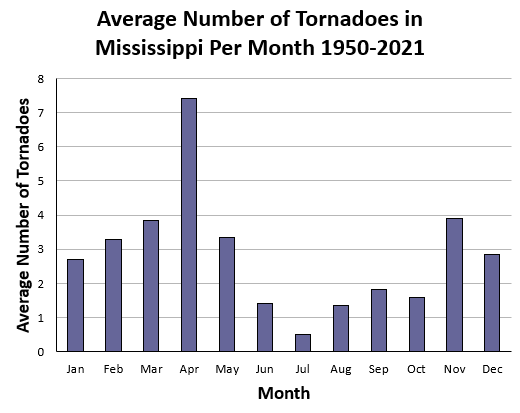